| Written by Christian Aadal

Table of contents:
In our first part of the RTLS 101 series, we explained what RTLS is, which technologies are used and where RTLS is mostly applied. In this second part, we want to discuss the basic components and the setup of such a system.
What are the Basic Components of RTLS?
The time at which assets are tracked is an important aspect of an RTLS. With this data, timestamps and visibility become possible. This is interesting as you can see assets passing through an area or monitor single objects in a defined room or process. An ideal Real Time Location System is able to accurately identify, locate, track, and manage assets or people and help you and your Process Management System to make informed decisions based on collected location data (learn more about car logistics in our Volkswagen Success Story).
The main parts of such RTLS applications consist of three components: a tag or transponder, a receiver (a reader), and software that calculates the data. Due to the framework of the scenario, the total amount of components will be chosen to create the ideal RTLS.
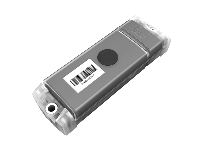
A tag or transponder is used to uniquely identify that item or person. The tag can be mounted on the object or temporarily attached (imagine a lanyard for a person). A (passive) tag receives a signal from a receiver and responds back with its unique ID (a book in a library). Still, it can also transmit the initial signal if it contains an internal power source like a battery. This is called an active tag and is used in hospitals for mobile instruments or at big parking lots for parked cars.
Transponder technology can be based in many different ways:
- RFID: RFID (Radio-Frequency Identification) is a technology that uses electromagnetic fields to identify and track tags attached to objects automatically. The tags contain electronically stored information. Common in inventory management, RFID offers a quick and efficient method of data transfer without physical contact or line-of-sight requirements. Learn about RFID tracking.
- Bluetooth beacons: Bluetooth beacons are small wireless transmitters that use Bluetooth Low Energy (BLE) technology to send signals to nearby smart devices. They enable location-based services in various applications, such as indoor navigation, proximity marketing, and asset tracking, by providing real-time information based on the user's location.
- Smart devices: Smart devices in Real-Time Location Systems (RTLS) refer to electronic gadgets embedded with sensors, software, and connectivity to exchange data with other devices and systems over the internet. These devices collect and process data, enabling precise tracking and management of assets or individuals in real-time for various applications.
- Wi-Fi tags: Wi-Fi tags are small, wireless devices used in Real-Time Location Systems (RTLS). They communicate using Wi-Fi networks to transmit location and other data. These tags enable tracking and managing assets or individuals within a Wi-Fi-covered area, widely used in industries for inventory management, security, and logistical purposes.
- Global Navigation Satellite System (GNSS)/Global Positioning System (GPS) tags: GPS tags in Real-Time Location Systems (RTLS) utilize Global Positioning System technology to provide location information. They send signals to GPS satellites, enabling precise outdoor tracking of assets or individuals over wide areas. These tags are ideal for logistics, fleet management, and any application requiring extensive geographical coverage.
- Ultrasound tags: Ultrasound tags are devices in Real-Time Location Systems (RTLS) that emit high-frequency sound waves to communicate their position. These tags are used for precise indoor tracking and positioning, as they can accurately measure distances by calculating the time it takes for sound waves to reach receivers.
- Infrared tags: Infrared tags in Real-Time Location Systems (RTLS) use infrared light to communicate their location and identity. These tags emit signals detected by infrared sensors, facilitating accurate indoor positioning and tracking of assets or individuals. They are commonly used in environments where line-of-sight communication is feasible and reliable.
A receiver is the middleman: it is hardware with a power source connected to a network that sends and receives signals from several tags. The receiver's task is to forward the data - including the ID of the object or person, timestamp, and distance - to back-end host computers or databases. In some systems, receivers can be existing infrastructure, but in others, receivers must be added to the running system environment.
Typically, receivers can be :
-
Readers: In Real-Time Location Systems (RTLS), readers are devices that receive signals from tags to determine their location. These readers process the data from various tag types like RFID, Wi-Fi, or ultrasound, and relay this information to a central system for tracking and managing assets or individuals in real time.
-
Location sensors: Location sensors in Real-Time Location Systems (RTLS) are advanced devices that detect and track the position of objects or individuals within a specific area. These sensors can use various technologies like RFID, Wi-Fi, Bluetooth, ultrasound, or infrared to gather locational data. They capture signals emitted by tags attached to assets or individuals, process this information, and accurately pinpoint locations. This data is then transmitted to a central system for analysis and management. These sensors are crucial in diverse applications such as inventory management, asset tracking, personnel monitoring, and facility navigation, offering precise, real-time location tracking to enhance operational efficiency and safety.
-
Access points: In Real-Time Location Systems (RTLS), access points are networked devices that connect RTLS tags to a central system. They receive signals from tags, using technologies like Wi-Fi or Bluetooth, and relay this information for processing. Access points enable continuous, wide-area tracking and communication within the RTLS infrastructure.
-
but also beacons
- or smart devices
The software can be everything - from software integrated into the receiver hardware to multiple software instances, like location engine software, middleware, and application software on a host computer. The complexity depends on the desired functionality of the system. The software architecture of such a RTLS application distinguishes:
- Firmware: Firmware in the context of Real-Time Location Systems (RTLS) refers to the embedded software programmed into the hardware of RTLS devices like tags, readers, and access points. This software controls the basic functions of the hardware, enabling it to communicate, process signals, and execute specific tasks essential for the RTLS to operate effectively. The firmware dictates how the device interacts with other components in the system, manages data transmission, and ensures accuracy and efficiency in tracking and location determination. Regular updates to the firmware can enhance performance, add new features, and address security vulnerabilities, ensuring the RTLS remains reliable and effective.
- Application software: Application software in the context of Real-Time Location Systems (RTLS) is a specialized suite of programs designed to process and utilize the data collected by RTLS hardware components like tags, readers, and access points. This software plays a pivotal role in interpreting the raw location data into actionable information. It can manage and analyze the movements and locations of assets or individuals within a monitored environment, providing real-time insights and historical data analysis.
The job of RTLS application software includes tasks like data visualization, generating maps and heat maps of asset movements, setting up geofences or alert zones, managing asset inventories, and producing analytical reports. It can also integrate with other enterprise systems to automate processes, enhance decision-making, and improve overall operational efficiency. The software is typically user-friendly, allowing end-users to easily monitor and manage the system without requiring extensive technical knowledge.
- Middleware: connects firmware and application software
Further reading: Who is using RTLS in brownfield operations?
How do you set up RTLS?
Setting up a Real-Time Location System (RTLS) involves several critical steps and considerations. First, the specific requirements of the environment and application must be assessed, including the size of the area to be covered, the type of assets or individuals to be tracked, and the desired level of accuracy. Based on these needs, an appropriate RTLS technology (such as RFID, Wi-Fi, Bluetooth, or Ultra-Wideband) is selected.
The installation involves placing tags on the items to be tracked and strategically positioning readers or sensors throughout the area to ensure optimal coverage and signal reception. Access points are also set up to relay data to the central system.
Key factors to consider include the physical layout of the environment, potential signal interference sources, the battery life of tags, system scalability, and integration capabilities with existing software or systems. Security and privacy concerns, especially when tracking individuals, must also be addressed. Proper calibration and testing are crucial to ensure the system functions accurately and meets its intended purpose.
Such a factory setup or a big offshore installation will quickly become complex. Depending on the to-be-achieved goals, the RTLS setup will vary by accuracy, tracking concept, technology and amount of hardware needed, as this picture may show:
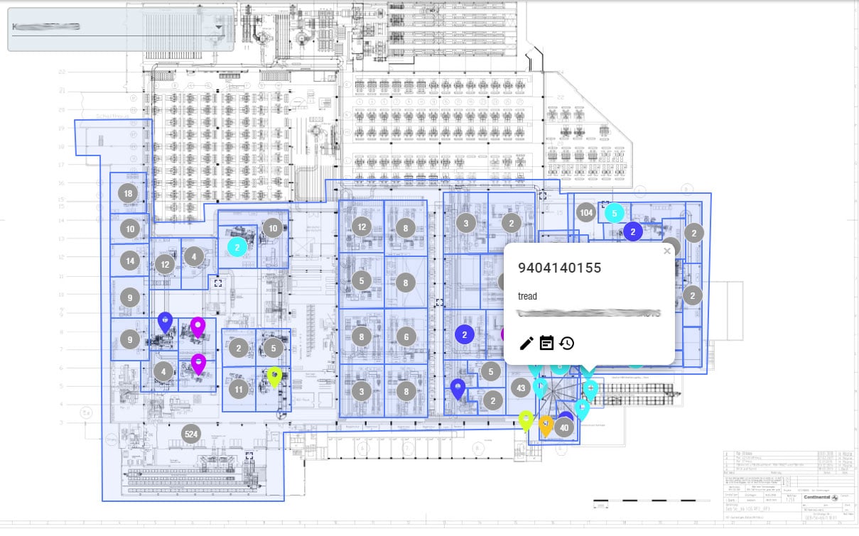
Once the tag signal is found, three antennas read the tag’s unique ID and send the signal strength value to the database. The software receives that information and calculates the location. All technologies can give a more accurate location if more than one receiver captures a tag’s signal. Trilateration is a common method using at least three fixed points (typically receivers), and the positions of these points must be known to calculate the position of the object between them. Triangulation is similar but uses known distances and the angles of each known point.
Do you want to understand RTLS technology? Download our RTLS eBook, no registration needed!
FAQ
What are the essential components of an RTLS system?
An RTLS system consists primarily of three components: tags or transponders, receivers, and software. Tags, attached to assets or individuals, send signals that are picked up by receivers. These signals are then processed by software, which calculates the data to provide real-time location information. Tags can be active or passive, and receivers can range from readers and location sensors to access points, depending on the system’s needs.
How do you choose the right RTLS technology for your needs?
Selecting the right RTLS technology depends on several factors: the size of the area to be covered, the type of assets or individuals to be tracked, and the desired accuracy level. Technologies like RFID, Wi-Fi, Bluetooth, Ultra-Wideband, and others have specific strengths and limitations. Consider the physical layout, potential interference sources, system scalability, and integration with existing systems when choosing the technology.
What are the key considerations for the successful implementation of an RTLS?
Successful implementation of an RTLS requires careful planning and consideration of several key factors. These include the physical layout of the environment, potential signal interference, battery life of tags, scalability of the system, and integration with existing software or systems. Security and privacy, especially when tracking individuals, are critical. Proper calibration and testing of the system are crucial to ensure accurate functioning and to meet the intended purposes. Additionally, understanding the specific goals of the RTLS setup, such as accuracy or tracking concept, is vital for a tailored solution.
Takeaway
The setup of a Real-Time Location System (RTLS) is a multifaceted process that is pivotal for enhancing operational efficiency in various industries. It revolves around understanding the key components - tags, receivers, and software - and selecting the right technology based on specific needs like coverage area, asset type, and desired accuracy. Successful implementation hinges on addressing factors such as environmental layout, signal interference, system scalability, and integration with existing infrastructures.
For a deeper understanding of RTLS and its transformative potential in manufacturing, we encourage you to explore our comprehensive RTLS eBook. Additionally, delve into Asset Agent, our industrial RTLS solution, to discover how it revolutionizes asset tracking and management in the manufacturing sector.

Continue reading the complete overview: Real time location systems in manufacturing and indoor logistics
Glossary
Beacon refers to a signaling device that emits light, sound, or radio waves to guide, warn, or transmit information. Traditionally, beacons were used in lighthouses and fire signals. Modern beacons include Bluetooth Low Energy (BLE) devices used for proximity marketing, navigation, and asset tracking. They enhance location-based services in industries like retail, transportation, and emergency response by enabling real-time communication with nearby devices. (2)
Sources:
(1) Sebastian Thiede, Brendan Sullivan, Roy Damgrave, Eric Lutters: Real-time locating systems (RTLS) in future factories: technology review, morphology and application potentials, Procedia CIRP, Volume 104,
2021, Pages 671-676, ISSN 2212-8271, https://doi.org/10.1016/j.procir.2021.11.113.
(2) Hargrave, J. (2018). Beacon Technologies: The Hitchhiker’s Guide to the Beacosystem. Apress.
Note: This article was updated on the 5th of August 2025. This article was partly created with the assistance of artificial intelligence to support drafting.

Author
Christian Aadal, Product Manager


