| Written by Mark Buzinkay
Table of contents:
- What happened at El Teniente's Andes Norte project?
- Why isn't seismic monitoring alone enough to protect underground workers?
- How does continuous personnel-location data complement geotechnical monitoring?
- How do you know who is in a seismically affected area after an event?
- How does location data support exclusion zones and re-entry?
- How does personnel tracking support search and rescue?
- How can mines demonstrate exposure management to regulators?
- What should a safety manager ask when evaluating a personnel-location system?
- FAQ
- Takeaway
- Glossary
What happened at El Teniente's Andes Norte project?
On 4 August, Codelco temporarily suspended development and construction at Andes Norte, part of its El Teniente mine in Chile. Six months of technical analysis had pointed to an emerging seismic phenomenon distinct from the risks historically known and managed there, linked to the greater depth of the works. Engineering & Mining Journal reported the announcement (1). Other areas of the mine continue to operate, and existing monitoring and safety measures remain in place.
The pause came about a year after a magnitude 4.2 event caused a fatal collapse at El Teniente in July 2025. Chilean trade press reports six workers died and that Codelco's own investigation called it the largest seismic event in the mine's history (2). Codelco has not announced a restart date.
Why isn't seismic monitoring alone enough to protect underground workers?
Seismic monitoring detects and locates rock events, but it does not tell you who was nearby when one occurred. It also cannot reliably forecast them. NIOSH notes that, despite decades of research, rockbursts remain notoriously difficult to predict (3), so the focus has shifted from prediction to managing the risk.
That limit matters because models are built on past behaviour. Codelco described the Andes Norte phenomenon as distinct from the risks it had historically known and managed, and said its behaviour is still being investigated. When a hazard sits outside established parameters, thresholds and trigger levels calibrated on earlier experience may not fire when they should. Seismic activity monitoring remains essential, but it cannot guarantee that the warning arrives before the event.
Seismic data also describes the rock, not the workforce. A network can report that an event of a given magnitude occurred at a given location. It cannot say whether ten people or none were in that area, or whether they were working, travelling or waiting at a refuge chamber. Without that information, exposure is inferred from shift plans, radio calls and memory.
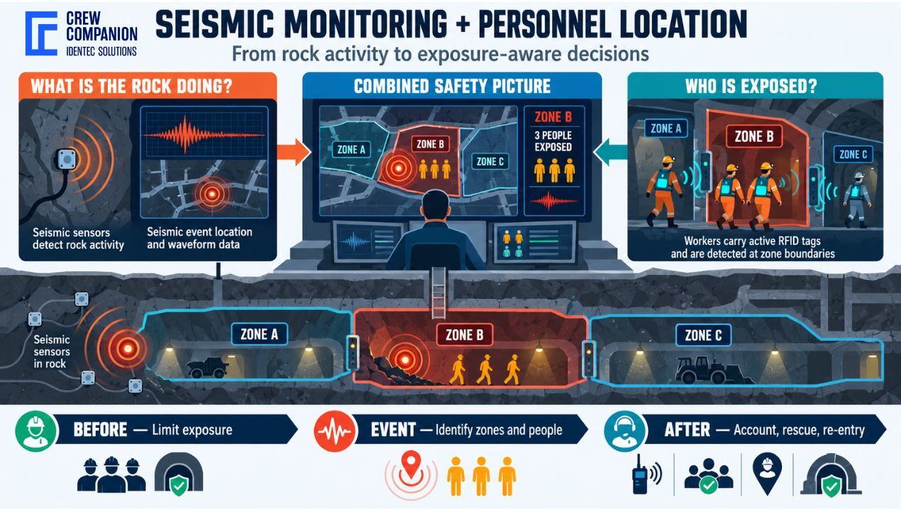
Two questions therefore need answers. Geotechnical teams ask, "What is the rock doing?" Safety managers must also ask, "Who is exposed?" NIOSH notes that most deep hardrock mines already run seismic systems, so the second question is where many operations still have room to improve. Answering both gives the mine a complete picture, not half of one.
Learn more about operations and mining safety training
How does continuous personnel-location data complement geotechnical monitoring?
Continuous location data does not replace seismic activity monitoring. It turns hazard information into exposure information, so that a seismic alert can be followed by a concrete safety decision. It does this in three phases.
Before an event. Location data shows how many people work in zones the geotechnical team considers elevated-hazard, and for how long. That lets safety managers set and check limits on the number of people in those zones, and adjust schedules or work sequences. The goal is to keep production going while keeping exposure as low as practicable.
During and after an event. When a seismic event is recorded, location data shows who was in or near the affected area at that moment. Instead of relying on shift lists, radio roll calls or supervisors' memory, the control room can start from a current list. This shortens the time between an event and an informed response.
Later, for review and improvement. Historical location records show how many people were exposed to high-hazard zones over weeks or months, and whether exclusion rules were followed. That supports incident reviews, internal audits and conversations with regulators. It also helps geotechnical and safety teams see whether controls actually reduce exposure over time.
The two systems are strongest when you can view their data together. Mapping a seismic event onto the same zones the location system uses gives one shared picture of hazard and exposure.
Be realistic about what this achieves. Location data does not prevent seismic events, and it does not make an unsafe area safe. It reduces and documents exposure and speeds up response, and those benefits are valuable on their own terms.
How do you know who is in a seismically affected area after an event?
With zone-based location data, the control room can filter personnel by zone within seconds of a seismic event. This is the strongest practical argument for combining the two systems, because the first minutes after an event are when accurate information is scarcest. An illustrative response workflow looks like this:
- Event detected: the seismic system reports the event time, magnitude and approximate location.
- Zones matched: the event location is mapped to the affected zones and to a defined buffer around them.
- Personnel listed: the location system lists everyone whose last-known position falls inside those zones.
- People contacted: the control room calls the listed individuals or their supervisors and confirms status.
- Gaps escalated: anyone who does not respond, or whose last-known location is inside the affected area, is escalated immediately to the emergency response team.
- Response directed: rescue and inspection teams are sent where the data shows people were last recorded.
This replaces manual reconciliation at the moment when time matters most. It also gives the emergency team a defensible starting point for decisions, rather than a best guess.
Three points make this workflow reliable in practice. First, decide in advance how far the "near the event" buffer extends, because rock can be affected beyond the epicentre, and different zones may need different buffers. Second, remember that zone-level location shows where someone was last detected, not their exact position or condition, so treat it as a starting point for confirmation. Third, rehearse the workflow in drills so the control room can run it calmly under pressure and the mine can find coverage gaps before an emergency does.
How does location data support exclusion zones and re-entry?
When seismic activity rises, geotechnical teams often restrict access to certain areas. Location data helps enforce that restriction by showing whether anyone is still inside and by alerting teams if someone enters a restricted zone. After an event, it also helps verify that an area is clear before re-entry procedures begin, and it records who re-entered and when. Geotechnical and safety experts make re-entry decisions. The location system supplies the facts those decisions depend on.
An exclusion zone is only as good as the mine's ability to see whether it is being respected. Signage, barriers and instructions all depend on people following them, and on supervisors knowing who has and hasn't. Zone-based location data adds an objective check. The control room can see in real time whether the zone is empty, who is nearby, and whether anyone has crossed the boundary. That is particularly useful when the restriction is temporary and changes with the seismic picture, because temporary rules are the easiest to miss.
The same data supports each stage of a restriction:
- Setting the zone: before the boundary takes effect, the system lists who is inside, so they can be told to leave and their exit can be confirmed.
- Holding the zone: alerts flag any entry while the restriction is active, so the control room can contact the person immediately.
- Lifting the zone: before re-entry, the record shows the area was cleared and that no one entered without authorisation, which supports the decision to reopen it.
- Documenting the zone: the log shows who entered under which authorisation and for how long, which is valuable for reviews.
Two cautions apply. First, a location system shows tagged people, so untagged visitors, contractors or equipment operators are a gap, and the mine's tagging discipline must be strict. Second, an empty zone on screen is one input, not proof of safety. Re-entry should still follow the mine's inspection and approval procedures. Location data matters because it grounds decisions in a verified record rather than assumptions.
How does personnel tracking support search and rescue?
After a collapse, rescuers need to know who is missing and where to start looking. Last-known-location data narrows the search area and helps prioritise resources. It also supports muster and refuge-chamber accountability by showing who has reached safety. Research on IoT-based command centres describes RFID positioning combined with geofencing and real-time evacuation information as a practical basis for emergency response (4).
The first problem in any underground emergency is uncertainty. Who was underground? Who was in the affected area? Who has already evacuated? If the answers come from paper lists and radio calls, they arrive slowly and can be wrong. A location system provides a live headcount and a per-person last-known position, so the incident commander can begin with a working picture instead of building one from scratch.
That picture supports several decisions:
- Accounting: comparing the list of people underground with those confirmed at surface, muster points or refuge chambers shows exactly who remains unaccounted for.
- Search priority: last-known positions help rescue teams decide which areas to reach first, and which routes are most likely to matter.
- Resource allocation: knowing roughly how many people may be affected, and where, helps size the response and quickly brief external rescue teams.
- Communication with families and authorities: a verified list of who is missing supports accurate, timely information, which matters for trust after an incident.
As with any location data, interpret it carefully. A last-known position is where a tag was last detected, not necessarily where the person is now, especially if they moved through an area without coverage or the infrastructure was damaged. Treat it as strong guidance for the search, not a guarantee. This is also why survivability, covered earlier, is so important: the value of the data in a rescue depends on its still being available when the network is stressed.
How can mines demonstrate exposure management to regulators?
Regulators increasingly want evidence of how mines control risk, not only how they monitor it. In Chile, Sernageomin has intensified its oversight of El Teniente (5) following the 2025 accident, and it stresses timely, accurate reporting. Time-stamped location records can document how many people were in high-hazard zones, when, and under which restrictions. They support compliance evidence, but they do not by themselves satisfy regulatory requirements.
The underlying point is that "we monitor the hazard" and "we manage exposure to the hazard" are different claims, and only the second speaks directly to worker safety. Seismic data shows that a mine is watching the rock. It does not show that the mine limited how many people were in harm's way, or that its exclusion rules worked. Location records fill that gap with objective, time-stamped evidence that can be reviewed after the fact.
In practice, such records can help a mine show:
- how many people worked in defined high-hazard zones over a given period;
- that restrictions were applied when seismic activity rose, and how long they lasted;
- that zones were verified clear before re-entry, and by whom;
- how quickly the mine established who was affected after an event.
This kind of evidence is also useful internally. It lets safety managers compare periods, test whether new controls reduce exposure, and brief management with facts instead of impressions.
Be careful about how the value is framed. Requirements differ by country, mine type and regulator, so mines should confirm what applies to them with their own compliance and legal teams. Location data is one part of a wider risk-management system that also includes ground support design, monitoring, procedures, training and governance. It is strong evidence of exposure control, but it is not a substitute for any of those.
What should a safety manager ask when evaluating a personnel-location system?
Choosing a system is easier when you start from the questions that matter for seismic risk, not from a list of features. These questions can structure a vendor discussion or an internal review:
- Resolution: what location resolution do we need in critical zones versus general areas, and does the system deliver it where it counts?
- Integration: can the system integrate with our seismic monitoring and control-room systems, so that events and zones can be viewed together?
- Survivability: how does it behave when infrastructure is damaged, and does it retain and make last-known-location data accessible in an emergency?
- Alerting: can we define exclusion zones, and how quickly and reliably do alerts reach the control room?
- Coverage discipline: how do we tag contractors and visitors, and how do we handle lost or unworn tags, so the data can be trusted?
- Reporting: what historical reports can we produce, and how long do we retain data?
- Data governance: how is worker data handled, who can access it, and for what purposes?
- Worker trust: how will we involve workers and unions in the rollout, so the system is understood as a safety tool?
The last two deserve particular attention. A location system works only if people wear the tags and accept the system, and that acceptance depends on being open about what is collected and why. Clear rules on access, purpose limitation and retention protect both workers and the mine, and they show that the system exists for safety, not surveillance.
Finally, ask about the practicalities of running the system day to day: installation effort, maintenance, training for control-room staff, and how the vendor supports drills and emergency exercises. A capable system that the team cannot operate confidently under pressure delivers less than a simpler one that they can.
FAQ
Can personnel tracking predict rockbursts?
No. Rockbursts remain very difficult to predict, even with advanced seismic monitoring. Personnel tracking does not forecast events. It reduces and documents exposure, and it speeds up response when an event occurs.
Does location data replace seismic monitoring?
No. Seismic activity monitoring shows what the rock is doing, while location data shows who is exposed. They answer different questions, and underground safety needs both.
What is the difference between UHF and LF active RFID?
UHF generally offers longer read range for area-level awareness, while LF works at short range for precise detection at checkpoints and zone boundaries. Combining them balances coverage and precision.
Can location systems integrate with seismic monitoring systems?
Often yes, through control-room software or data interfaces, but it depends on the vendors and the mine's architecture. Confirm integration options early, including how seismic event locations map to tracking zones.
Takeaway
Seismic monitoring and personnel location answer different questions, and underground safety needs both. Geotechnical teams track the rock; safety managers must also know who is exposed when that rock behaves unexpectedly, as Andes Norte illustrates. Neither system prevents seismic events, but together they reduce exposure and speed decisions.
For underground mine safety, a zone-RTLS such as Crew Companion, using UHF and LF active RFID, shows who is in which zone, helps enforce exclusion areas during elevated seismic activity monitoring alerts, and verifies clearance before re-entry. It also leaves a record for reviews and regulators (see: miners safety).
Delve deeper into one of our core topics: Mining safety
Glossary
The Andes are the world's longest continental mountain range, stretching about 7,000 kilometres along South America's western edge through seven countries. They rise chiefly because the oceanic Nazca Plate subducts beneath the South American Plate, a process that also drives frequent earthquakes and volcanism. The same tectonic history concentrated the porphyry copper deposits mined at El Teniente and elsewhere in Chile and Peru, making the range both a geological force and a mining heartland. (6)
References:
(1) e-mj
(2) https://chilepaisminero.com/el-teniente-dos-sectores-paralizados-a-un-ano-del-accidente/
(3) https://www.cdc.gov/niosh/bulletin/2023/rockbursts.html
(4) https://pmc.ncbi.nlm.nih.gov/articles/PMC9346949/
(6) Oncken, O., Chong, G., Franz, G., Giese, P., Götze, H.-J., Ramos, V. A., Strecker, M. R., & Wigger, P. (Eds.) (2006). The Andes: Active Subduction Orogeny. Springer. https://link.springer.com/book/10.1007/978-3-540-48684-8
Note: This article was partly created with the assistance of artificial intelligence to support drafting. The head image and the illustration was created by AI.

Related Articles
Related Product